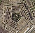
Berkas:Pentagon satellite image.jpg

Ukuran pratinjau ko: 632 × 600 piksel Resolusi lainnyo: 253 × 240 piksel | 506 × 480 piksel | 809 × 768 piksel | 1.079 × 1.024 piksel | 2.261 × 2.146 piksel.
Ukuran nan usali (2.261 × 2.146 piksel, ukuran berkas: 4,02 MB, tipe MIME: image/jpeg)
Riwayaik berkas
Klik pado tanggal/wakatu untuak mancaliak berkas pado maso tu.
| Tanggal/Wakatu | Miniatur | Dimensi | Pangguno | Komentar | |
|---|---|---|---|---|---|
| kini ko | 19 Oktober 2022 00.08 |  | 2.261 × 2.146 (4,02 MB) | Cryptic-waveform | File:Pentagon-USGS-highres.jpg cropped 29 % horizontally, 39 % vertically using CropTool with precise mode. |
| 14 Juni 2005 00.40 |  | 565 × 536 (108 KB) | Neutrality | U.S. Geological Survey satellite image of the Pentagon, taken April 26, 2002. The reconstruction of the section damaged in the September 11 terrorist attacks is visible on the building's west (l |
Pamakaian berkas
Laman nan mamakai berkas ko:
Pamakaian berkas global
Wiki nan mamakai berkas ko:
- Pamakaian pado ar.wikipedia.org
- Pamakaian pado bh.wikipedia.org
- Pamakaian pado bn.wikibooks.org
- Pamakaian pado da.wikipedia.org
- Pamakaian pado de.wikipedia.org
- Pamakaian pado en.wikipedia.org
- Pamakaian pado en.wikibooks.org
- Pamakaian pado en.wikinews.org
- Pamakaian pado en.wikiquote.org
- Pamakaian pado eo.wikipedia.org
- Pamakaian pado fi.wikinews.org
- Pamakaian pado fr.wikipedia.org
- Pamakaian pado fr.wiktionary.org
- Pamakaian pado he.wikipedia.org
- Pamakaian pado hy.wikibooks.org
- Pamakaian pado id.wikibooks.org
- Pamakaian pado it.wikipedia.org
- Pamakaian pado it.wikiquote.org
- Pamakaian pado ms.wikipedia.org
- Pamakaian pado nn.wikipedia.org
- Pamakaian pado ru.wikinews.org
- Pamakaian pado scn.wikipedia.org
- Pamakaian pado tl.wikiquote.org
- Pamakaian pado vi.wikipedia.org
- Pamakaian pado vi.wikibooks.org
- Pamakaian pado zh.wikipedia.org
- Pamakaian pado zh.wikinews.org


