
Berkas:Bhutan - Location Map (2013) - BTN - UNOCHA.svg

Ukuran nan usali (Berkas SVG, 250 × 250 piksel, ukuran berkas: 520 KB)
_-_BTN_-_UNOCHA.svg)
Arunachal Pradesh shown separately is integral part of India.
Ikhtisar
| Katarangan |
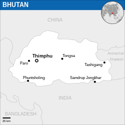
English: Locator map of Bhutan. |
| Tanggal | |
| Sumber |
English: Bhutan Locator Map (ReliefWeb), ESRI, UNCS, The Times Atlas of the World |
| Pambuek | |
| SVG genesis | Gambar vektor ini dibuat menggunakan Inkscape. |
Lisensi
- Sanak bebas:
- untuak babagi – untuak manyalin, manyebarkan, jo mangirimkan karya
- untuak mancampua – untuak mangadaptasi karya
- Di bawah kondisi barikuik:
- atribusi – Sanak musti maagiah atribusi karya ko jo caro nan ditantuan dek pambuek atau pamacik lisensi (tapi indak jo caro apo pun nan mancaminkan Sanak dipaso atau panggunoan Sanak pado karya tasabuik).
 This map is part of a collection of 216 free country maps, created by the UN Office for the Coordination of Humanitarian Affairs (OCHA), to be used in print, web or broadcast products.
The ReliefWeb Location Maps released here are maps that highlight a country, its capital, major populated places and the surrounding regions. Attribution Requirements
Using the map without modifications: ensure that the sources and the disclaimer are below the map. Credit as follows: "Credit: OCHA". For use with alteration: remove the OCHA logo and disclaimer following any modification to the map, but keep the data sources as mentioned below the map. Credit the modified map as follows: "Based on OCHA map". You are responsible for the content of your map. We are keen to receive your feedback and hear how you used OCHA's maps. We would be grateful if you would notify us by e-mail and share your work with us. UN Disclaimer
The designations employed and the presentation of material of this map do not imply the expression of any opinion whatsoever on the part of the Secretariat of the United Nations concerning the legal status of any country, territory, city or area or of its authorities or concerning the delimitation of its frontiers or boundaries. |

|
Informasi tekstual (e.g.timestamp) setelah terlihat di gambar itu sendiri telah dipindahkan ke metadata gambar dan/atau halaman deskripsi gambar. Ini membuat gambar lebih mudah digunakan kembali dan lebih netral bahasa, dan membuat teks lebih mudah diproses dan dicari. Commons Manipulasi Meta Data menempatkan informasi tekstual yang terlihat dalam gambar. Semua lisensi yang diterima di Commons mengizinkan jenis modifikasi ini sebagai karya turunan.
Jika informasi atribusi dihapus dan gambar tersebut bukan domain publik, ganti tag ini dengan {{Attribution metadata from licensed image/id}}.
|
Riwayaik berkas
Klik pado tanggal/wakatu untuak mancaliak berkas pado maso tu.
| Tanggal/Wakatu | Miniatur | Dimensi | Pangguno | Komentar | |
|---|---|---|---|---|---|
| kini ko | 26 Desember 2022 06.38 | | 250 × 250 (520 KB) | Wikijahnn | File uploaded using svgtranslate tool (https://svgtranslate.toolforge.org/). Added translation for ca. |
| 19 Nopember 2022 08.17 |  | 250 × 250 (520 KB) | Pengetik-AM | File uploaded using svgtranslate tool (https://svgtranslate.toolforge.org/). Added translation for id. | |
| 5 Januari 2016 13.12 |  | 250 × 250 (519 KB) | Wereldburger758 | Resized page to drawing. Removal watermark. Validation of image. | |
| 14 Maret 2014 05.43 |  | 254 × 254 (514 KB) | UN OCHA maps bot | == {{int:filedesc}} == {{Information |description={{en|1=Locator Map of Bhutan. {{OCHA map}}}} |date=2013 |source=[http://reliefweb.int/map/bhutan/bhutan-location-map-2013 Bhutan Locator Map (ReliefWeb)] |author=[[w:United Nations Office f... |
Pamakaian berkas
Laman nan mamakai berkas ko:
Pamakaian berkas global
Wiki nan mamakai berkas ko:
- Pamakaian pado az.wiktionary.org
- Pamakaian pado bn.wikipedia.org
- Pamakaian pado ca.wikipedia.org
- Pamakaian pado es.wikipedia.org
- Pamakaian pado haw.wikipedia.org
- Pamakaian pado id.wikipedia.org
- Pamakaian pado kg.wikipedia.org
- Pamakaian pado ki.wikipedia.org
- Pamakaian pado mai.wikipedia.org
- Pamakaian pado pl.wikipedia.org
_-_BTN_-_UNOCHA.svg)